Pitchoff Mountain

9/22/20

This is one of the last peaks that I need to complete the Lake Placid 9ers, and despite never really hearing any hype about it, I was so ready for this hike. Weather looked promising, and despite not sleeping the night before, I left my house at 7am with a sleepy puppy in tow and made it to the Cascade/Pitchoff parking lot on rt 73 by 10:15am. I was meeting my buddy Steve, and saw him parked in the very first lot closest to the trailhead, but I had to drive up the road a ways to get a free spot. Fortunately I found one – even mid-morning on a Tuesday, these lots for Cascade FILL UP. I took a moment to pack away my water and get Juno prepped for the hike while Steve made his way up to us.

Soon we left the car and walked on the side of the road to get to the trailhead. I had NEVER noticed this trailhead before; it’s literally right off of rt 73, there’s no lot directly in front of it, and it’s across the road from Cascade. We reached it at 10:50am, signed in at the register, and started up the trail. We were happy to note hardly any people signed in at the register, despite the packed parking lots!

Not 5 minutes after leaving the register, the trail started to climb. And boy did it. I was thinking to myself, there’s not enough caffeine in the world for me right now, so I stopped to take a few puffs of my inhaler to prep for the climb, and decided to down a Gu packet for good measure – these puppies are packed with nutrients and electrolytes, and though I’d never tried one, I’d heard great things. The taste was fine but the texture…let’s just say that “Gu” is an appropriate name. Coupled with the Nuun that I’d downed on the drive up, my body was ready, whether or not I was. So we heaved our packs back on and continued our upward slog.

I wanted to laugh; was this how the trail was going to be the whole time?? It didn’t even give us a warm-up, just immediately UP. I reminded myself, the first 20 minutes are always the worst, and 10 minutes later we had crested a ridge. The trail after that was GORGEOUS. We were up on a ridge that dropped off on either side, with a healthy vibrant canopy enveloping us, bright pops of orange, red, and yellow peeking through with the sunlight filtering through from above. I must have said many times “Woooow it’s so pretty!” at nothing really in particular but at the environment as a whole. I felt so content strolling this gentle dirt path along the mountain. We really weren’t particularly far from the road, but we were high enough and within enough trees that none of the sounds reached us.

We happily bopped along for the next 20 minutes of easy walking. I was so stricken by the beauty of the sunlight-dappled forest floor that I paused constantly to snap photos, sometimes without warning so that Steve would nearly slam into me. Sorry Steve! We reached our first lookout peering over rt 73 at 11:20am. I made sure to hook Juno onto her leash for these lookouts – curious rapscallion that she is, she gets a rush out of getting right up to the edge to look over 😬.

We hung out for a minute or two in no particular hurry, then found our next lovely perch some minutes later. I was feeling so much more energized than when I started, something I attribute to the Nuun and Gu. Nevertheless, we took a break here to set our packs down and snack on some fruit while looking over the map. There’s an icon on the map for something called the “Balanced Rocks”. I’d never heard of them, but on the map it looked like the trail to it hooked around and back from the main trail up pitchoff. It was hard to tell exactly where it was and where we were though, so we kept asking ourselves – “Do those rocks look balanced to you?” every time we spotted some boulders. We remained at our nice lookout for another 10 or 15 minutes. As we were packing up to leave, a happy older couple joined us, very excited to pet Juno. They were coming up behind us and asked if this lookout was the “Balanced Rock”. We replied that we thought it was further up the trail, chatted for a bit, then hoofed it on out.

Soon after, we reached some awesome boulders we had to craftily scuttle up, which obviously Juno immensely enjoyed, after which the trail started to descend a bit and wrap around, going deeper into the mountain ridge. At about noon, we heard voices up ahead and paused to let them pass. It was another sweet couple who warned us that the next 15 minutes would be a steep scrambley hell. I figured that maybe they weren’t used to the Adirondacks and assumed it wasn’t actually a nightmare – just as we reached the base of the steepest section of this trail.

This part was tricky to navigate, but honestly I thought it was pretty fun. Tough, obviously, but fun….That’s actually really easy to say now, sitting at home on my couch a day later; my sentiment may have been a little different in the moment….There were many places where we could see that many people had come down different routes. Honestly, it was a hot mess, a choose-your-own-adventure if you will, so we basically just let Juno run ahead and followed in her path. I stopped for just a few moments to admire some tiny mushrooms and the smoothest birch bark, but mostly we just slowly clambered up.

At one point, I could see Juno’s intentions to leap onto a narrow rock ledge on the side of a boulder and barked DON’T YOU EVEN THINK ABOUT IT! She assessed the ledge from another perspective, thought better of it (maybe because I was still shrieking at her) and turned away to effortlessly lope away up the steep mountainside. Showoff.

Amazingly, it only took us 30 minutes to reach the top, where we came to a junction that another couple had warned us not to miss on their way down. Written in tiny letters we could read “Balanced Rocks ->” on the top and “Summit <-” on the bottom.

We bore right to investigate the so-called balancing rocks we kept wondering about and were deposited by the trail onto a stunning slope of bare rock, with yet another boulder.

While we examined the boulder, again wondering, “Does it look balanced to you?” a Ranger approached from up ahead and laughed when I told her we kept wondering if rocks seemed balanced or not to determine if we’d arrived! She said to keep going, and described what we’d see ahead. I’ll not spoil it for you just yet, but we wasted no time in heaving our packs back on and trailblazing forward to figure out what was the deal with these balanced rocks 1.6 miles from the trailhead. Let me tell you……they are QUITE a deal.

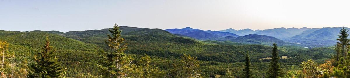
I was in AWE. I couldn’t close my mouth, it just about dropped open all the way to my knees. I tossed my pack on the ground, grabbed my camera, and basked in paradise. I wanted to stay there taking photos forever. It was just…perfect. We could see SO MUCH! From the olympic center on the side of Mount Van Hoevenberg, to Mount Marcy and Mount Jo, even all the way to the ski jumps in Lake Placid, blanketed in a shroud of blazing red beneath a hazy sky.

I told him to “do something with his hands” because they looked awkward…

I had so much fun playing with my Peakfinder app and identifying all of the mountains in front of us!

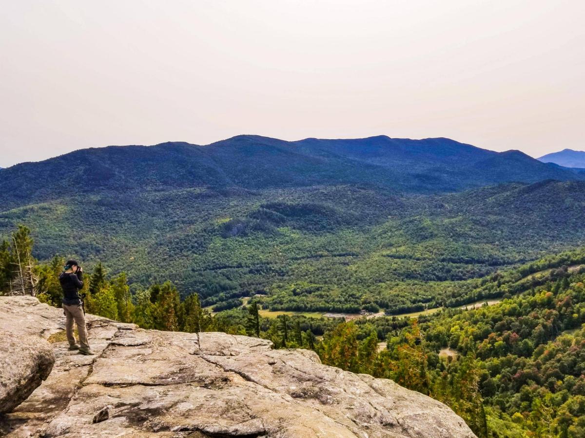
I climbed up onto THE balanced rock (I think) to get a better perspective, and of course Juno threw a fit until she was up there with me! This slope of bare rock is characterized by huge boulders lying around and atop cracks and crevasses that cut straight down into the mountain below.

We remained for 30 minutes. It was so nice to be in no hurry today and to linger for as long as felt right. I took plenty of time to stretch my legs, hydrate (both myself and the pup), and soak in the splendor. At 1pm we turned away and padded back up to the junction, where the first couple we’d met that day was just finishing the steep climb. They remarked that this was NOT the “moderate, family-friendly trail” an acquaintance had told them it was, to which I responded, “It kind of is an easy one, compared to the rest of the Adirondacks”. Even the “easy” mountains here are still rugged. I feel for people who get suckered into thinking climbing an ADK mountain is like a walk in city park. Anyway, we pointed them toward the balancing rocks, and informed them that they’ll know it when they see it, just keep going until the end. Then we made our way toward the actual summit of pitchoff.

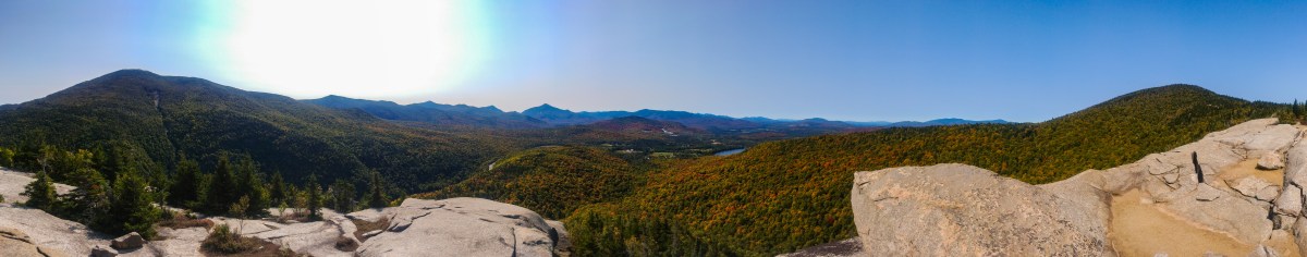
Looking back from the Balanced Rocks to see the summit of Pitchoff.

The trail descended a bit from the junction before climbing again. After about 30 minutes we reached what we thought may be the summit, from which there were no views but there WAS a very large boulder. With no signs, we recalled on the map that the true summit is the first high point along the Pitchoff range coming from the West trailhead (as we had), and from there it descends a bit. We continued on hoping for a nice place to stop, enjoy lunch, and stretch.

Sure enough, a few minutes later at about 1:30pm, we reached an open outcropping with a steep slope down the side of the ridge. I was a bit nervous with Juno so I leashed her to me, however it wasn’t really necessary – I had her food, cheese, and water, so she wanted nothing to do with exploring. We three sat and enjoyed our snacks, pondering how the view here doesn’t hold a flame to the one at the balanced rocks.

Still, we had the summit to ourselves, and we waved up to the constant filter of ant-sized human shapes we could see moving about the summit of Cascade across the way.

Again I took the opportunity to play with my Peakfinder app! I have so much fun with this thing. It was identifying peaks alllll the way into Vermont, which we could see as a pale blue silhouette on the horizon beneath a haze of wildfire smoke. My favorite of these was “Breadloaf Mountain”.

We stayed until 2:00pm, then took our leave. We were certain by now that the summit was just the big boulder we passed on the way up, so we patted it with our hands and strolled back to the junction, where we AGAIN encountered that same kind, happy couple for the third time that day. They asked us if the boulder was the actual summit, and said they didn’t explore further but were confused not to have seen us! We talked for a bit, then passed them to fall with style down the steep scrabbly slope. We quickly caught up to another group heading down with difficulty…I myself employed the ADK Butt Slide technique of, you guessed it, sitting on the near-vertical rock slabs and shooting down them on my ass. Luckily my pants are sturdy, and at the next tricky spot I opted instead to climb down backwards, facing the mountain and lowering 1 foot at a time.

That mess of rocks and plants and dirt….is the trail.

Before long we were at the bottom of the steepest section and felt light on our feet as we climbed back up to the ledge along the ridge to view the cascade lakes. We’d repeatedly caught up to the group in front of us, so they kindly let us pass by while gushing at Juno, much to her delight. She knows EXACTLY how cute she is.

A glimpse of Cascade Lakes

We made great time, and at 3:30 we were back at the register signing out while I lazily tried to get a pic of me and Juno together, without much success.

NAILED IT

Walking back on the road I was excited to see the “balanced Rocks” from the road! Another landmark I can now happily identify on my drives through the mountains.

Juno slept the entire 3 hour drive home, after which we scarfed down a meal (sushi!!!) and were in bed by 8:30pm. This hike is in my books as one of my new favorite trails.

Pitchoff Mountain: 3500′ Elevation Gain: 1400′

Round Trip Distance: ~5 miles

Total Duration: 4.5 hours including who knows how long at summits/overlooks

Happy Hiking!

Big Crow Mountain

9/15/20

Despite the name of this one, it is the shortest of the Lake Placid 9ers at 1.4 miles round-trip. Immediately after finishing Bear Den Mountain in Wilmington, I and my two hiking buddies (and Juno) made our way up the narrow dirt road toward the Big Crow trailhead. The drive up gave us a fantastic view of the mountain we were about to climb, and I was thinking, “Wow, that sure seems like a steep climb!” until I realized the road we were on took us nearly all the way up! Since this hike was so short, I opted to leave my pack behind and take only the essentials up with me to give my back a break. We lingered just for a moment at the trailhead to enjoy some beautiful huge red leaves, then made our way up to the register at about 3:15pm.

The trail started off relatively flat, but before long we were certainly gaining some serious altitude. With an elevation gain of 570′ over only 0.7 miles, of course this was going to be a steep one!

The bright side of this hike is that before you know it, you’re at the top! It took us half an hour to reach the summit at about 3:45pm.

The view at the top was a little bit clearer than at our previous summit, but not by much. Still, there is no better way to spend an afternoon than looking down on the adirondacks with it’s reddening foliage.

After about 15 minutes, we took our leave. I was trying to be in my car by 4pm; it’s a 3 hour drive home, and I didn’t want to spend it in the dark! As we were heading out, we passed the sweetest little family – a mom and dad with 3 little kiddos – who were so excited to greet Juno as we descended past them.

Within 20 minutes we were back to the flatter part of the trail, where I spotted a HUGE orange mushroom that I must have missed on our way up! Jeepers this thing was the size of my foot!

On the way down, we talked about how this trail is a perfect little Adirondack hike; it has all the elements of a real high peaks trail, just scaled back. We arrived back at our cars at 4:25pm. The lot, which had been so busy just over an hour before, had emptied out. I learned this lot is also another trailhead for Hurricane mountain! I had no idea there were multiple ways up Hurricane, but that explained how there were so many cars but almost no people on our trail. Not that I’m complaining! As I drove home, I watched the sun set in front of me, that same odd orange ball that I had seen that morning, with the distinct aura of being seen through a screen of wildfire smoke.

Big Crow Mountain: 2815′ Elevation Gain: 570′

Total Distsance: 1.4 miles

Total Duration: 1 hr 10 minutes, including time at top

Happy hiking!

Bear Den Mountain

9/15/20

Now that summer is basically over, the crowds have dispersed, weather is cooler, and I have Tuesdays free, I figure it’s time to get my lazy butt back into the mountains. I’m starting to push myself again to see if I’m ready to hit those high peaks, so I thought a good place to start would be with the Lake Placid 9ers. My plan was to go up Bear Den, then head into Keene to try for Big Crow as well.

I left home by 7am and drove the three hours to Wilmington, with the most bizarre rising sun ahead of me. The only time I’d seen a sun looking like a floating orange ball in the sky, with no aura, is when I’d seen it through smoke from wild fires. Considering the circumstances out west, that isn’t exactly a crazy assumption. I made it to the trailhead of the Flume Trails off of 86 where I met two of my very best friends, Gavin and Steve!

We tried to sign in at the trailhead (“tried” because there were no free spaces on the sign in sheets) and set off on the wide mountain-biking trail at 10:30am, with Juno zipping between the trees left and right. My map didn’t have very clear markings for these trails, but fortunately I snapped a picture at the register of the trail map, which came in handy as we reached each of many many junctions. We stayed on the Corridor trail heading towards the Upper connector trail.

After some climbing, we reached a beautiful “sugar bush” which Gavin was particularly excited about, full of strong maple trees just starting to drop their bright leaves on the forest floor. Gavin gushed at all of the maple trees, hugging a select few special ones, while I oohed and aahed at the MUSHROOMS. The mushroom situation on this trail is unreal. I had to fight the urge to pick them every time I found a large strand of shroomies, so instead, I took photos of them!

It was around this time when I started to realize how out of shape I am. I’m trying to assess if I’m ready to get back into the high peaks, logging 20-mile days with a full pack, so I thought I’d try hiking with my full pack for these smaller hikes to see where I’m at. DANG BUD, IT’S ROUGH. Of course I wouldn’t tell my hiking buddies at the time but my god I felt like I’d be better off dragging my carcass along the trail with my arms! Instead, I insisted on frequent breaks to catch my breath, using the opportunity to get Gavin talking about trees to extend our break (Sorry Gav! I’m shameless), before continuing on. It wasn’t a particularly long hike, but it was a bit more strenuous and a bit more UP than I suppose I was expecting!

Along the way, we passed only one older couple heading down, so I was looking forward to having the summit to explore on our own. We climbed and climbed and finally I could see a break in the trees! We scrambled up to a gorgeous view of Whiteface Mountain practically looming over us at 12:30pm.

We three dropped our packs to soak in the view and have some lunch, and after a few minutes Gavin and I realized we lost Steve! Jokingly I said, ‘Maybe he took a wrong turn and wound up on Whiteface!’, but instead we found a narrow trail leading further up. As it turns out, we weren’t actually on the summit. We left our packs behind, and I felt positively bouncy! I felt so light without the weight of my pack as I bopped my way along the trail. After just a few more minutes we were at a slightly higher outcropping with a slightly nicer view, where we found both Steve and Juno.

Naturally, I immediately set about capturing some photos. I was feeling very frustrated as I stalked around, crouching and leaning to get various shots of the landscape, but the sky was just so….UGLY. It was ugly. There was not a single cloud in the sky, so logically the sky should have been blue, right? But no, it was this greyish-whitish haze that settled to a ruddy orange around the peaks in the distance. It made all of my shots look slightly out-of-focus. One of my biggest pet peeves as a photographer is when people saturate the sky when taking pics, so the sky just looks totally white instead of showing any dimension or clouds…..AND THAT’S WHAT ALL OF MY SHOTS LOOKED LIKE! But they weren’t saturated, just…ugly! So that was the second indication of the day that we were seeing massive amounts of smoke, high in the atmosphere, that had drifted in from the wild fires out west.

Despite the ugliness of the sky, we marveled at the pops of red sprouting in the canopy beneath us.

We hung out for a while regardless, and I turned my focus to a lovely model to distract from the ugly sky – Juno! Her poses were really on point. Check out this saucy look:

At 1:15pm we decided to head back down so that we’d have time to make it to our 2nd peak of the day. Right about at this time we encountered our second pair of people for the day, a couple who also thought the first rocky outcropping was the summit. We directed them to the path to the top, and hustled down the trail.

The descent was much more smooth than the climb, and I was thrilled to find that my knee didn’t hurt! Since we were making good time, I didn’t feel guilty about stopping and climbing into a stream to get some pics.

As I was climbing out of the stream, I noticed Juno acting real odd next to me up on the bank. She was jumping around, wiggling and scratching, and I noticed a small bright yellow wriggling mass sticking out of her haunch: a hornet was repeatedly stinging her viciously in her hind hip! I swatted it away, but it continued to dive-bomb us so we ran ran ran back to the trail to the boys. She was still acting erratic and scratching at her head when Gavin saw another hornet fly out from behind her ear. We looked back at where she and I had been near the stream and spotted a hive on the ground, surrounded by the swarming assholes. Once we were sure Juno was fine, we wasted no time in getting the hell out of there.

Before long, we were back to the mountain biking trails above the marshy pond. We saw a few odd groups of older folks slowly ambling up the trail; for some reason they seemed quite strange to me. Maybe it was the way they were dressed, or that they gave us wary looks as we passed and wouldn’t make eye contact. Whatever the case, we made it back to the parking lot at about 2:30pm, had some snacks, and headed off for Big Crow. Juno never stopped running today, so the first thing she did was pass out in the back seat. Poor thing thought we were done for the day!

Bear Den Mountain: 2650′ Elevation Gain : 1300′

Round Trip Distance: ~4.5 miles

Total Duration: ~4 hours, including time at the summit

Next up : Big Crow Mountain

Bald (Rondaxe) Mountain

12/28/2019

It’s been several months since our last hike, and a day in the woods was desperately needed for my own sanity. We’d reviewed the weather for this day over the past few days, and it appeared to be the only sunny day in the forseeable future! So we’d decided to head to Old Forge to try to catch the sunset on Bald Mountain. Now we don’t have the best track record for successful sunset hikes…Our first ever hike together was up Indian Head in March 2018, with the goal of seeing the sunset….Sparing any details, let’s just say we missed the sunset…by 6 hours! 

We made it to the trailhead at 2:30pm and were OVERWHELMED by how sunny and bright it was! (There should be a special font for sarcasm…). Heck, the weather guys couldn’t have been more wrong, it was just a regular overcast grey day. We weren’t about to let that dampen our spirits though, especially Juno, as she neared flight speeds while careening down the trail.

We were surprised by the number of cars in the parking lot for a hike on a winter day, not realizing just how popular this trail is. Nevertheless, we signed in at the register, took our starting photo, and headed off.

Look at Juno’s face! 😂

Soon after we began, a pair of people with two sweet bouncy dogs followed behind us, so we decided to stop and wait for them to be sure the dogs were friendly with Juno and to let them meet. Unfortunately they were not wearing appropriate footwear and decided smartly to turn back when we came to our first steep section, down which a large group of kids were struggling, also lacking appropriate footwear. We decided to put on our microspikes right at the beginning of the trail, noticing how icy conditions were immediately; I have no clue how people wearing smooth leather street boots made it so far up that mountain, and I’m surprised we didn’t find anyone with a broken ankle along the way!

We navigated even the trickiest sections of “steep” eroded trail with the help of our microspikes, and in no time at all we arrived at the first lookout.

Juno has the interesting habit of rolling and flopping around in the snow, and I was seriously worried she would roll herself right off the edge of the mountain, so we wasted no time here and continued on our way.

After this point, the minimal climbing was already just about over, and the trail began to follow along the spine of the mountain ridge. We found it a very exciting and interesting landscape, though it was a bit daunting at times to walk on the balance beam ridge covered in ice. We didn’t opt to use it, but there is a herd path through the woods skirting the ridge for those too harrowed to skate across it.

A few short minutes of rock-hopping later and we had our first glimpse of the firetower! Juno often likes to run ahead, but this time she chose to scamper right up the firetower steps to get a better view before we even got there.

The first time Juno went up a firetower, I had to practically carry her back down; this time, she led the way! How far she’s come. It was clear by now that there would be NO SUNSET due to the overcast skies, but we chose to hang out for a while and enjoy the brisk air on our skin for a while longer. Figures, we finally make it up in time for the sun to set, on a day when there is no sunset!

And of course we took some obligatory summit selfies, but we FORGOT TO PACK VICTORY CHOCOLATE! 😭 A mistake that wont happen again!

Since there was no sunset, there was no sense in waiting around for darkness to fall, so we headed down while it was still light. We made it down in no time at all, and were again incredibly grateful for our microspikes. We saw so many people on the trail with sneakers and street shoes struggling where we were able to walk right on by. Juno of course has the gracefulness of a mountaingoat in most conditions, but even she is cautious on the ice!

We made it all the way back to the trailhead and hopped into the car to head home. I was ecstatic that I made it a whole hike without any debilitating knee pain, and so so refreshed after a few hours in the woods.

Juno in her natural habitat, on her couch with her pillows and blanket

Enjoy those winter hikes, and WEAR SOME DAMN HIKING BOOTS AND MICROSPIKES!

Bald Mountain: Elevation – 2350′ Elevation Gain – 500′

Round Trip Distance: 1.9 miles

Total Duration: <2 hours including time at summit