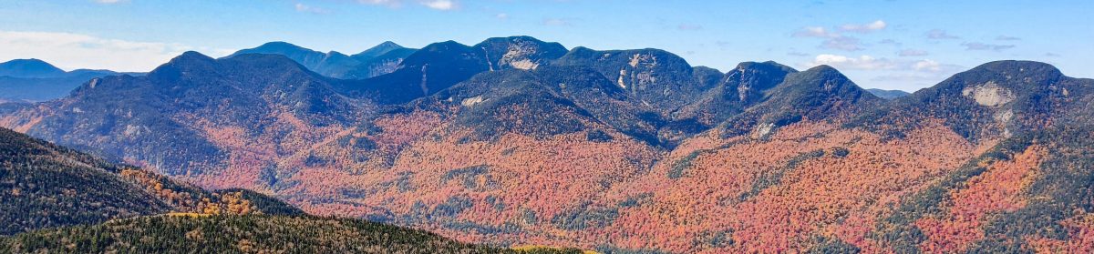

While there are infinite possibilities in how to group these peaks and hike the 46, below you’ll find common groupings and routes, along with approximate distance and other helpful info. Groups are listed in order of difficulty. If you’re just beginning your 46er journey, try starting at the top of this list. Or, if you’re completely new to hiking or to the Adirondacks, try doing one of the other challenges first, such as the Tupper Lake Triad, or the Saranac Lake 6er, or the Lake Placid 9er!
If you are new to hiking in the Adirondacks, be sure to invest in the High Peaks Map and Guidebook. Review them before setting out on your trek, and also bring them with you in an accessible location in your pack or pocket to reference frequently while out. In addition to reviewing the map and guidebook, I also plan each hike by reading blogs and trip reports from other hikers – I’ve linked my own trip report entry for each peak I’ve done below. Note that the newer editions of the map don’t show any trail indications for the ‘trailless’ peaks. See the trip reports for images from my older map for these – I find they’re pretty helpful!
Not sure what to pack for your hike? Check out my packing guide here: Gear and Tips.
As always, be sure to follow the tenets of Leave No Trace any time you’re recreating in the ADK wilderness. See below for details, taken directly from the link above.
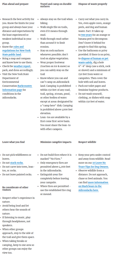
Source: https://www.adirondackcouncil.org/page/leave-no-trace-tips-for-the-adirondack-park-244.html
The 46 High Peaks of the ADKs
- Cascade and Porter –
- 6.2 miles
- Marked trails
- Trailhead on rt 73
- Big Slide –
- 8 miles (minimum)
- Marked trails
- Trailhead at The Garden
- Highly recommend going up via the Brothers
- Street and Nye –
- 9.1 miles
- Trailless
- Trailhead at the Adirondack Loj
- Whiteface and Esther –
- 9.5 miles
- Marked trails
- Trailhead at ASRC
- Recommend walking back on the road for the views, if hiking when the road is closed
- ** This would be a good one to save for last, to have friends/family meet at the top by driving up the road**
- Giant and Rocky Peak Ridge –
- 10.4 miles (minimum)
- Marked trails
- Trailhead at Roaring Brook Falls
- Popular Alternate – do this range as a traverse, starting from Rt 9. Can also hike RPR alone as an out-and-back from this starting point to avoid the col between Giant and RPR.
- The MacIntyre Range: Algonquin, Iroquois, and Wright –
- 10.2 miles (minimum, if done as ‘out and back’)
- Marked trails
- Trailhead at Adirondack Loj
- Recommend doing as a loop, ascending Boundary peak from Lake Colden (would add ~3 more miles)
- Recommend hiking Wright last so as not to ‘orphan’ Iroquois! Wright is much easier to come back and get by itself; to get Iroquois though, you have to go over Algonquin or Boundary peak first, depending on the route
- Popular Alternate (and the way I hiked it) – make it a loop, going up to Boundary Peak from Lake Colden, summiting Iroquois first, then Algonquin, and Wright last.
- Colden –
- 12 miles (minimum, out and back)
- Marked trails
- Trailhead at the Adirondack Loj
- Recommend doing as a loop (would add ~2 more miles)
- Tabletop and Phelps –
- 12.3 miles
- Trailless on Tabletop, marked elsewhere
- Trailhead at the Adirondack Loj
- Recommend climbing Tabletop first, then Phelps
- Nippletop and Dial –
- ~13 miles
- Marked trails
- Trailhead at St Huberts
- Recommend starting on Lake Rd, climbing Nippletop first, then Dial, and coming down Bear’s Den
- Colvin and Blake –
- 13.7 miles
- Marked trails
- Trailhead at St Huberts
- Recommend starting on Lake Rd, and climbing Indian Head and Fish Hawk Cliffs along the way (would add 1.6 more miles)
- Marshall –
- ~14 miles
- Marked, then trailless up to Marshall
- Trailhead at Upper Works or ADK Loj
- Recommend descending via Cold Brook to see the plane wreck
- Skylight, Gray, and Marcy –
- 18 miles
- Marked trails, trailless up Gray
- Trailhead at either ADK Loj or Upper Works
- Can split up Marcy from the other two
- Popular Alternate – many folks start their 46 with Marcy alone starting from the Loj, and doing Skylight and Gray by themselves later on. Choice is yours!
- The Santanoni Range:Santanoni, Couchsachraga, and Panther –
- 17 miles
- Trailless
- Trailhead on Tahawus Rd, before Upper Works
- Recommend climbing in winter.
- Recommend absolutely not skipping Couch in favor of the other two – come back for Panther or Santa if you have to break it up, not Couch!
- Cliff and Redfield –
- 18.8 miles
- Marked, then trailless up to each mountain
- Trailhead at Upper Works
- Recommend camping overnight at Uphill Leanto
- The Lower Great Range – Sawteeth, Gothics, Armstrong, Upper Wolfjaw, Lower Wolfjaw –
- 17 miles
- Marked trails
- Trailhead at St Huberts
- Can split it up – Sawteeth Gothics and Armstrong (with Pyramid) one day, Upper and Lower Wolfjaw another day
- Popular Alternate – start from The Garden or the Rooster Comb lot. Whatever you do, don’t miss the steep climb up Pyramid as it purportedly has some of the best views in the ADKs despite not actually being a high peak!
- I hiked this in from the garden, camping near wolf jaw lean-to, tackling all 5 and going back up and over Gothics to come back down, then hiked out the next day. I’d rank that route as being harder than HaBaSa and don’t suggest including Sawteeth if done this way – do Sawteeth as a separate hike by itself.
- The Seward Range: Seward, Donaldson, Emmons, and Seymour –
- Over 21 miles, if done all together
- Trailless
- Trailhead at Corey’s Rd
- Recommend splitting it up. Seward Donaldson and Emmons (15.9 miles) on one day, Seymour (14 miles) by itself on another day
- Dix Range: Macomb, South Dix, Grace, Hough, and Dix –
- ~16 miles, if done together
- Trailless
- Trailhead at Elk Lake Rd
- If splitting it up, try to get Macomb, S Dix, Grace, and Hough, then come back for Dix.
- Allen –
- 20 miles
- Trailless
- Trailhead on Tahawus Road, on the right side before reaching the Upper Works
- Can camp ~5 miles in to break it up
- Haystack, Basin, and Saddleback –
- 18.7 miles
- Marked trails
- Trailhead at The Garden
- Can split it up by camping
- Suggested to do in HaBaSa or counterclockwise order, rather than SaBaHa to ascend the notorious cliffs of Saddleback rather than descend them.

