6/26/21
My buddy Gavin had been telling me about Mt Adams for a while by this point, but I’d never made it a priority to go hike it. This particular day was rainy and we were planning to meet up with some friends that we hadn’t seen since before the pandemic, and thought Adams would be a perfect hike. We met at the trailhead at about 1:30pm, signed in at the register, and headed off. Our friends (David and Kelley) had two pups with them, and we were a bit anxious to see how they did with Juno (and how Juno did with them), but after an initial sniff they all just pretended the other didn’t exist and ignored each other completely!
Just a few minutes after starting, we came across a water crossing (the Hudson River) with a rickety old bridge. Surprisingly, all 3 dogs walked right across it with only a little trepidation. We noted this spot as a proper swimming option for the way back….
Soon after we started the hike, rain started to come down a bit heavier so we donned our rain gear and hats as we padded along. Thankfully it was just the right temperature to not be cold from the rain or too hot from wearing the rain gear. However, we did nearly miss this turn in the trail because we were keeping our heads down!
Soon after we came upon a nice view of Lake Jimmy.
This trail is also the way to go to climb up Allen Mountain. It’s certainly not the most popular high peak, but I’d thought enough people would be doing it that the trail would be very well established. However, after another water crossing, the foliage closed in around us as we navigated on soggy puncheon through a dense patch of the forest.
About 30 minutes after leaving the trailhead, we saw what looked like a little abandoned building. The doggies went to explore but we admired from a distance, eager to carry on. (Just to be clear, all 3 of the dogs have remote collars and fantastic recall, not to mention we carry their leashes with us just in case. They stay on the trail and don’t run out of control.)
Not a minute later we arrived at the junction to Mt Adams, where the trail deviates from the one going towards Allen. We veered to the left and continued on up.
For the next 20 minutes or so the trail was still quite flat, and had been since the beginning of the hike, so we were getting a bit worried that we were, in fact, climbing Adams and not Allen by mistake?? I, however, wasn’t worried enough not to stop and ‘AWWWW’ at a little orange salamander dude on the trail.
Well, you know what they say, be careful what you wish for….
Of course the trail did start climbing eventually. And once it did, it was fairly steep as we had all of the elevation gain over only about a mile. We had actually stopped before this stretch to take a gander at the map to make sure we were on the right path (spoiler alert: we were). The climb had been gentle though and not technically challenging, but as we gained more and more ground the climbing got more and more tricky, undoubtedly made worse due to the fact that we were hiking in the rain….
Despite looking a bit intimidating, the rocks weren’t actually very slick due to their slightly porous texture, though we did avoid trodding on tree roots, knowing how they turn into a slip-n-slide when wet…
It was so nice hiking with these guys. Somehow we seamlessly took turns walking in pairs and chatting – first me and Gildo, then me and Kelley, then David, and we kept rotating positions. It did seem to make the hike go faster, until I loudly mentioned during a slightly downhill portion that we were probably very close to the summit because so often a trail will climb and climb and climb, then go a bit down, and a bit up, then you’re there!
Yeah. For every mountain EXCEPT this one!
Every time one of us would complain about the seemingly endless climb, another would shout – ‘It’s ok! We’re almost there!’
**Do note that exactly 0 of the 4 of us had ever climbed this mountain before, and 4 of the 4 of us had no clue how far we were from the summit**
We stopped for a minute to stretch below yet another vertical pitch, wondering how much further it might go on (the trail is only like 2.6 miles to the top….we’re just out of shape 😀 ). Once we got our tails moving again, we took another handful of steps uphill and spied a metallic structure up ahead! The firetower!!
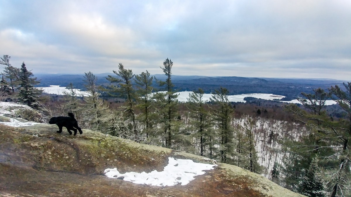
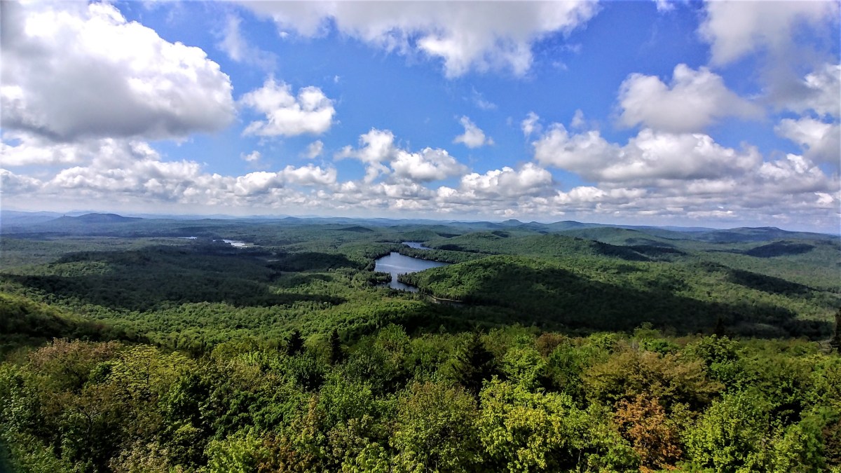
We made it at 3:20pm, almost 2 hours after starting from the trailhead. From the summit itself there are absolutely no views, but once you climb the ridiculously high firetower, you have purportedly the best firetower views in the Adirondacks. I was a bit bummed because it was looking like we were socked in, but I climbed up regardless.
And….just wow. The views were stunning. Once I had been there long enough I started to notice clouds forming down below and drifting quickly up before my eyes to join their brothers in the sky.
The scene seemed to change constantly, and I stayed up there for far too long to take it all in.
Unfortunately the views we didn’t have were those that would see the high peaks directly in front of us. We were SO CLOSE to Allen but, for the second time, I was robbed of a view of that peak (see Mt Redfield).
I stayed up there for half an hour (apparently, looking at the timestamps on my photos) before taking some pics of the crew hanging out and snacking wayyyy down below, and heading down for some snackaroos myself.
Combos and victory chocolate. Lunch of champions. We stayed chatting about all of our past adventures for another few minutes until we started to get chill from lack of activity and headed back down. I didn’t take many pics at all on the way down, trading my camera so I could focus much more on the descent. I am soooooo slooooooow going downhill, but David was a trooper and stuck with me despite my urging him to go on ahead because, and I’ll reiterate this, I am as SLOW AS DEATH’S GRANDMA.
We had only one close call involving the aforementioned slip-n-slide tree roots, but other than that the descent was actually pretty eventless. I relied heavily on my lovely trekking poles, pouring my weight into them to try and help my knees, and something must have paid off between my PT, walking 6 miles every day, and hitting the gym, because by the time we finished the steep sections I had no pain! Anywhere! Is the me we’re talking about?? Wow. It was a great feeling, friends.
As we neared the junction to the Allen trail, we heard voices and sure enough some of the groups that had been climbing Allen that day were on their way out. Of the woods, not…you know….Anyway, I was super impressed by them, not only for hiking a ~20 out-and-back to get Allen, but for doing it in the rain and facing Allen’s infamous ‘Red Slime’, an algae that coats many of the steep slides going up the mountain, making them nerve-wrackingly slick. One of the hikers mentioned how helpful his microspikes were with the slime, so I stowed that bit of information away for the future….
After letting some long-haul hikers pass us, we decided to stop and take a proper look in the little cabin we’d passed on the way up. The inside smelled a bit musty and contained an old sink, a cot, and a table with some laminated sheets of paper. Apparently the cabin had been saved from demolition in the early 2000’s and had been restored, which we noted as we glanced at the seemingly-new roof.
Another few sweaty, stinky moments later and we were back rounding the ponds where the puppers considered going for a dip.
However we held out for the cleaner water just near the trailhead. After seeing how much the dogs seemed to be enjoying themselves, Gildo and I decided to jump in too, clothes and all. It was a great opportunity to scrub off the mud and muck before heading to dinner together!
We hung out at the water for 20 or 30 minutes, throwing sticks for the dogs and enjoying the feel of the cold water on our tired bodies. We made it back to the cars at 6:30pm, 5 hours after starting, toweled off, and heading back into town for some grub feeling the cleanest we have literally EVER felt after a hike!
I hope to see you out there sometime soon, Allen hikers!
Until then, Happy hiking ❤
Mt Adams: 3520′ Elevation Gain: 1753′
Round Trip Distance: From the Map – 5.2 miles (distances vary wildly depending where you look, but this feels right)
Total Duration: 5 hours (including 45min at the summit and 30min swimming)