9/8/24
The dogs and I set off ambitiously to try to climb these two mountains on a Sunday morning. We had plans for the evening so I had to be back at the trailhead by 3pm. We arrived right at 10am so that gave us a 5 hour window.

I signed in at the register with my trusty companions, noting the warning for rattlesnakes in this area of forest.


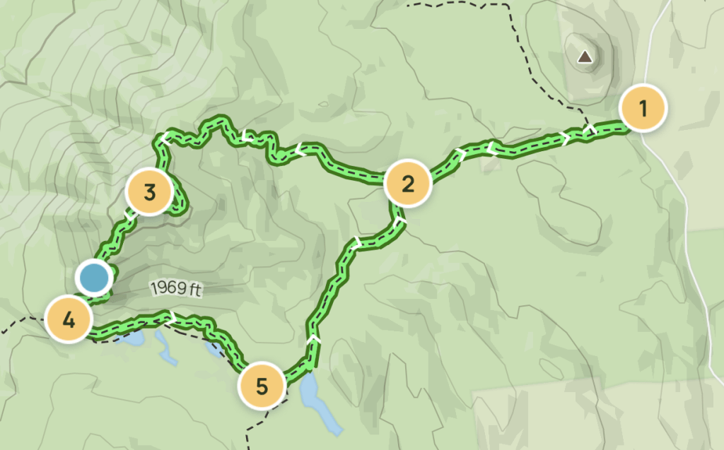
I didn’t find much information on this route online, so I’ll be as descriptive as possible for anyone else planning this trip! See the map below – my plan was to start on the blue trail to Bumps Pond, then go left at the junction (green section) to do this loop clockwise. Then up to Erebus, with the orange line approximately where I think I went up (there’s no official trail to the summit), down to Fish brook Pond, then up to Sleeping Beauty (light purple) and back down to the trailhead. There were a few tricky spots on this hike so I’ll reference this map later on.

This trail starts off wide and rocky with a gentle incline, and continues that way up to the junction with Sleeping Beauty at 0.6 miles.

I wasn’t sure how much water would be on the trail for the dogs, so we made sure to take advantage of the little streams we crossed along the way.

15 minutes from the trailhead and we were at the first of many junctions. To do the clockwise loop, we stayed left here.

Things got a bit steeper after that, with no pause in the climbing for the first 30 or 40 minutes from the trailhead. While rocky, the trail was still wide, easy to follow, and free of any blowdown.

We spotted this cool old stone wall on the way up to Bumps Pond too. I wish I knew the history here but with just a cursory search online, I couldn’t find much of anything. If anyone knows about this old wall, please let me know!

About 25 minutes after leaving the junction to Sleeping Beauty, the trail started to level off. I had to stop to admire the forest here, as it looks like something out of a fairy tale. Fitting, since we’re on our way to Sleeping Beauty!

A minute later and a little bit of descent and we were at the edge of Bumps Pond.


It’s only early September but this morning was COLD. Quite a shock after so many hot days. I could see the clouds rolling in and out, and felt the occasional icy cold raindrops spattering my face, but the tree canopy overhead did a pretty good job of keeping most of it off of us.

Just 2 minutes later and we were at the next critical junction. The sign was very warn, but it says “Fish Brook Pond -> , <- Dacy Clearing, Sleeping Beauty”. Looking at the map, I was very confident that this was the junction I’d have to turn left at, but the worn sign didn’t indicate a 3rd path toward Erebus.

There was however a much narrower trail to the left which had these blue markers on a tree (I marked this trail as Green on my map above) so I headed that way.

This was starting to look a lot more like an Adirondack trail. At this point in the day, I’d only see one pair of people coming down right at the beginning, and I guessed I wouldn’t be seeing anyone else on this particular trail either, judging by how little it appeared to be traversed.

This is when we started to see our first indications of the summer’s storms and the damage they left behind.

We ended up on top of a ridge, and could see light through the trees on either side, though it’s hard to capture in a photo.

Descending the other side of the ridge, the trail got a bit messier and a bit more Adirondack-y. Usually I kind of disagree with the rating All Trails gives to trails. The last few I did were marked as ‘Hard’ but I would have classified as ‘Easy’ (for a mountain, anyway). This one however I was starting to see that I might agree with the All Trails rating!


The trail down the ridge led us to a marsh that we had to navigate through. Still the trail was easy to follow and well marked.


We reached the junction to Shelving Rock Rd. exactly 1 hour after starting, 2.5 miles from the start. There were several signs on different trees to help orient, but the only indication that the intersecting trail led towards Shelving Rock rd was a small with marker with handwritten directions.


We continued straight/to the right towards Erebus, on what is the Yellow trail on my map above. It was clear right away that I’d have to keep my head up along this trail and not go too far without checking for trail markers. There’s more blowdown here and muddy sections of trail that make it really hard to tell which is the right way to go. This particular spot (below) almost got me – in my research I couldn’t find where the unofficial trail or bushwhack up to Erebus from the trail would start, and I was wondering if maybe this was it. Looking at the map though, that didn’t really make sense because I’d be going straight up a cliff, and I was certain there’d be some cairn or unofficial marker to point the way to Erebus summit. So I stayed to the left here to follow the red markers.

The trail went up and up and sure enough, at 11:20am, just 20 minutes after leaving the Shelving Rock junction, I saw exactly what I thought I might see – a little white marker with a hand written note and a small cairn marking the start of the ‘bushwhack’ up to Erebus (orange trail on my map above).


Ok this was very much a ‘choose your own adventure’ adventure. While hard to spot though, there was a defined route going up that I could follow if I paid attention.

When unsure, I looked around to see if there was evidence of many feet passing over the ground before me, such as this section of decomposing log that had been squashed.

And even better, some thoughtful yellow markers had been tied to trees to guide the way. Again, I had to move slowly and keep my head up to stay on ‘trail’, which was difficult because it was really very steep and messy terrain.

I reached the top of this steep hill 10 minutes after starting and the trail flattened out nicely.

Not to be deceived though, because the climbing continues up this last steep stretch before reaching the summit. I was pretty slow going here, while the dogs ran up ahead of me. When I pulled myself up the last bit, I lifted my eyes to look for my pups, and saw them both standing on top of a boulder ahead of me looking down at me to make sure I made it up alright.

Just another minute through the woods and I reached this little cairn and weird plate with Erebus Summit written on it, so I assumed I had made it. It took just 15 minutes from the junction.

We didn’t bother stopping to take a break because there was nothing to see and it was chilly! So we just turned right around and headed back the way we came.

Sometimes during steep difficult descents, I turn around and go down backwards so I can use my hands, which I’d definitely recommend here.

Because I was going backwards, I didn’t see Pluto just sit himself down to wait for my slow self. What a good dog.

On the way I noticed a view that I’d missed going up! Weather was really spotty, with rain one minute and sun the next, so I was really hoping to have clear skies by the time I made it to Sleeping Beauty.

On the way up I kept telling myself that it would be really easy to lose the trail coming back down, and I’d have to be really careful to pay attention….and yet, I still lost the trail. It wasn’t a big deal honestly because as long as you just keep going down in the right general direction, you’ll make it back to the trail. I did end up finding the little yellow ribbons again though, and was back at the junction just 15 minutes after leaving the summit. For any families working on the Lake George 12ster, I would not underestimate this particular summit. Personally I don’t think I’d bring young kids up here – there were plenty of opportunities for uncareful feet to take some nasty tumbles. I’d also note that this little junction might be hard to spot of doing this loop counterclockwise – the cairn and white marker were on the side of a tree that would be seen only when coming from the clockwise direction.

Back on the main trail we still were navigating around blowdown and muddy bogs, but it was so much easier than the trail up the Erebus that it felt like a breeze. 15 minutes later at 12:15 we reached the junction partway to Fish Brook Pond and turned to the right to go towards the pond.

Again, I don’t think this trail is traversed too often 😅 That’s the trail there, that muddy area cutting through the green.

It was on this stretch that I started to see the first signs of Autumn!


There was still some blowdown to navigate around on this section, but nothing that looked recent. My girl Juno smartly followed behind me to see how I’d navigate around the tricky spots, so she didn’t work harder than she’d need to.
We passed a little bog on the way and the pups enjoyed a drink of water at the first stream we’d seen in quite a while.


At 12:30pm, 2.5 hours after leaving the trailhead, we reached the junction at Fish Brook Pond. There was another sign that indicated the trail to the right was a bridle trail, but I was sure that was the way I wanted to go, so we turned right there.

I could see the lean-to on the other side of the pond, at the back of a clearing at the edge of the water, with some folks enjoying the view, but I still hadn’t seen anyone on my own trail since earlier that morning.

I have a bad habit of forgetting to eat while I hike, so even though we were on a tight schedule, I stopped at the edge of the water to give the dogs a snack and have one myself. We didn’t take a long break though – I only had 2.5 hours to make it back to the trailhead on time, and still had 4.5 miles to go. So on we went.

Saw this weird thing along the way, which apparently I deemed worthy of a photo, so there you go.

We reached the other end of the pond just before 1pm. I kind of regret not taking the longer route around the pond for the views, but I just didn’t have time.

There was a clearing at this trail junction with what looked like a fire pit and a few people hanging out there, so we went on by following the sign back toward Dacy Clearing.

The trail here was much more maintained that what I’d been on for most of the day and I was grateful for it!

I was so happily plodding along, lost in my thoughts, that I nearly missed the junction for Sleeping Beauty! If it wasn’t for the dogs going down the trail, and me noticing the little bridge down to the left, I would have passed it right up. The only marker is this little yellow one, with two others on the opposite tree behind me.


We hung a left and crossed a little bridge to start the trek up Sleeping Beauty at 1:20pm.


The trail up Sleeping Beauty from this direction was never difficult – it was uphill, but it had switchbacks and flat sections along the way. It took less than 20 minutes from the junction for the trail to level off.

Here was the second part of the day that I was unsure of – where to find the actual summit of Sleeping Beauty. I knew it wasn’t at the popular viewpoint up ahead, and that Sleeping Beauty has two kind of bumps – the true summit is on the first ‘bump’. See the bright blue dot on the purple trail on my map. THAT is the summit. I thought I’d see some indication of where to find it on the trail, but there was nothing that I saw – no cairn, no ribbons, no hand-written marker…nothing. But when the trail started to descend again, I stopped, turned around, and turned left (when coming from Sleeping Beauty viewpoint) into the woods. There were no markings or anything but it was easy to see which way was up, and to keep going until there wasn’t any more…up. I went maybe 50 feet and found this little cairn at 1:40pm, with nothing else to indicate that this was the summit, except that there was no other noticeable higher ground. So I assumed I’d made it.


We walked down a bit through a beautiful forest toward the viewpoint. I was really looking forward to getting there, but the weather wasn’t really cooperating! Back at Fish Brook Ponds, the sky was overcast and rainy, but I was hopeful it would clear up.

At 1:50, we reached the junction to the spur to the viewpoint of sleeping beauty, and headed straight along.

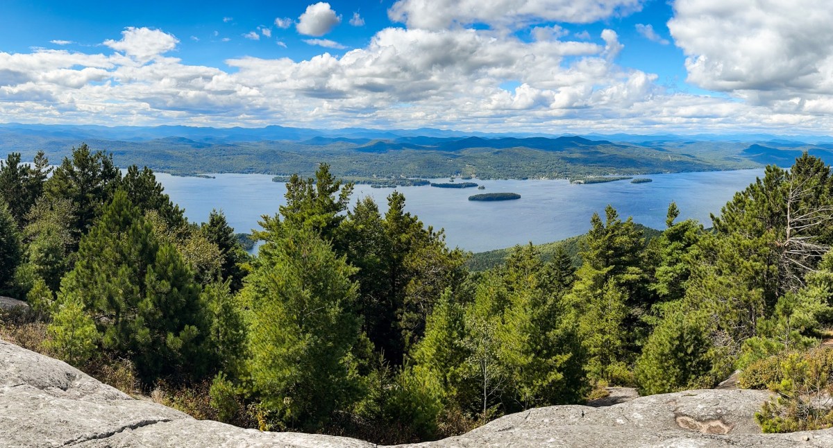
Just 2 minutes later, we were standing at a VERY windy, beautiful rocky overlook!


It was so beautiful with the clouds casting shadows over Lake George and the mountains beyond.


We finally sat down to take our first real break of the day and eat some lunch. We found a nice spot in the sun out of the wind and had the whole peak to ourselves for about 10 minutes before anyone else showed up.


I could see darker clouds moving in and the wind had gotten intense, so at about 2:15 I packed up our things and we started making our way back to the trail, leaving behind a few groups of people still enjoying the lookout.


We reached the junction a minute later and stayed to the right this time. The trails run parallel for a bit and I was careful to stay on the one marked as dark purple on my map.

This is clearly a well loved trail. There was no blowdown, but it was slick with rain from the morning and a bit steep and rocky in parts, so I made my way down carefully.

We passed just one group with two small kids making their way up, otherwise we had the trail to ourselves once again.


30 minutes after leaving the summit and we were at the last junction of our loop, at 2:45pm. Just 0.6 miles to go!

We reached the trailhead at EXACTLY 3pm, right on time. I signed us out of the register and gave a ranger some information about the trail conditions – I think they were expecting a lot of down trees from the wind blowing through that day, but I hadn’t seen any fresh blowdown all day thankfully. I got the doggies in the car and they wasted no time in getting some zzz’s. Until next time – happy hiking!


Erebus: 2527′
Sleeping Beauty: 2347′
Total Duration: 5 hrs
Total Distance: ~9.2 miles
All images are property of adktrailtalesandtails and may only be used with express permission.