
9/27/2024
I was really overdue for some time off work, so I took the day off and set out with the pups to tackle two more of the Lake George 12sters – Cat and Thomas! Only, not in that order. We rolled into the parking area on Valley Woods Rd at about 9am with just 2 other cars there, whose hikers were still getting ready for the hike.

I got the doggies suited up and off we went. I signed in at the register as the first hiker of the day.

I had a map with me, but took a picture of the one at the register just for good measure. The plan was to go up the ‘Cat and Thomas Ridge Trail’, summit Thomas, then Cat, then go back down ‘Cat Mtn Trl’ to ‘Thomas Mtn Edgecomb Pond Trl’.


The trail starts off wide and pretty much flat, albeit rocky, and parallels the Valley Woods Rd for a while.

Between the trail and the road is a nice little stream, lush and green.


After 3/4 of a mile of flat walking, the trail splits – right to go directly up Thomas, and left to go towards Cat.


We took the path to the right and the trail became a bit narrower and started climbing. It wasn’t particularly steep, and the terrain was easy to walk on, but the climbing did not let up.

Writing these trip reports really helps me to stay in the moment during my hikes. It’s so easy to get lost in thought and miss little details in my surroundings, like this little guy!

And this pretty miniature stream in a mossy jungle. I make a conscious effort to live in the moment and appreciate the little moments in life, and stopping to enjoy the beauty of the things around me helps me to do that.

Though the path all the way up looks identical (I took about 12 photos at different points and they all looked almost exactly like the one below -.-), I could sense the elevation we were gaining.

Stopping to look at the little flowers was also a good excuse to take a break and catch my breath! Being the first person on the trail, that made me the designated Spider Web Clearer for the day. Oh joy. I had to be mindful to keep my mouth closed so I didn’t get any extra unexpected protein in my diet.

Along the way I noticed some random rocks stacked on the side of the trail. I looked around but didn’t see anything to indicate that I was supposed to go that way to get to the summit. Per the tenets of Leave No Trace, please do not stack rocks found in nature. We should make as little impact as possible on the trail – “Take only photos, leave only footprints.” Not to mention that cairns typically indicate something important to draw a hiker’s attention to, so these little decorative stacks are misleading. Soooo I kicked them all over.

It took me a couple of tries to get a picture of this cutie – I took the first one just as it had hopped away, giving me a stunning photo of some leaves on the ground.

I was catching the most beautiful glimpses of blue sky between the trees and couldn’t wait to see the view from the summit.

We’re almost there! Just near the summit were some downed trees, casualties of the storms this summer, but the Trail signs and markers help guide the right way.


We did it! It took just 45 minutes to reach the summit of Thomas Mountain, 1.5 miles from the trailhead.

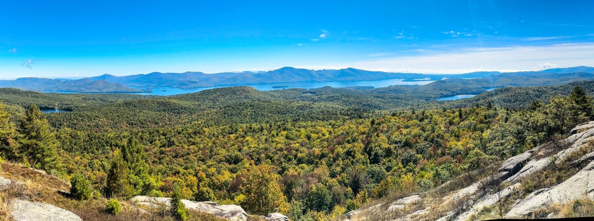
The drive to the trailhead was super foggy that morning. I was really hoping there would be some fog left in the mountains by the time I made it to the summit – I think it makes the view that much more beautiful! So I was so glad to see some remnants in the distance from the summit of Thomas.

Note that the true summit of Thomas is off the marked trail. This viewing point is the site of an old cabin and is considered the Official summit. No need to bushwhack to find the true one for sake of the hiking challenge.

We sat down just for a couple of minutes to take in the view, but we weren’t tired at all yet so I didn’t bother to unpack the snacks and water.

You can see our next stop, Cat Mountain, to the left of center in the picture below!

Just as we were getting ready to leave, a group of women was just making it to the summit. The puppies sat at attention.

Here’s another view of Cat. I know better by now that it’s never as far as it seems, but heck that does not look close by.

There’s only one thru trail going up Thomas, so no worries about taking the wrong path, unless you somehow get confused and go back the way you came. The path down is toward the right of the summit, and is pretty tricky right away.

There are loads of signs to help hikers stay on trail, but between the damage from the storm and the slick rocks, there were some difficult moments navigating.

Much of the trail looked like below – I just walked slowly and constantly looked for the next yellow marker on the trees.

We reached the flat section below the summit and continued through the forest, looking for our next yellow marker. On the map, it looks like we go up and around several bumps on our way to Cat, so I was expecting some ups and downs.

I was so grateful for all directions on the trail – I’ve never seen so many. At points this trail reminded me of so-called ‘trailless’ hikes I’d been on. Very rugged.


My goddddd were there a lot of spider webs. They were starting to demoralize me a bit, if I’m being honest. I am not the biggest fan of silky webs clinging to my arms, neck, face, and hands. I was starting to wonder if I’d have enough of them by the time I’d finished to knit a scarf.

While the recent rain made the rocky path more treacherous than usual, it also made the forest so verdant, vibrant and green.

There were several places where fallen trees made it tricky to stay on trail, but they’ve been down long enough by now that I could see where other feet had trod before me. It helps to have path-finding doggies leading the way too!


Here’s one of many spots I almost ate it, stepping on slick wet rock. At least it’s pretty.

I spotted this little glade through the trees and hiked a bit off trail to get to it. I could just imagine having a picnic here and reading a book in the sun.

I cannot emphasize enough HOW. MANY. SPIDER WEBS. I passed through. I think I invented some great new dance moves – one waving my arms alternately in front of me like an elephants trunk to clear the webs before my face does, and one to wipe them off of myself when I inevitable walk into them. There were several like the one below too – beautiful ornate webs with happy little spiders sitting in the middle. I tried to go around or under so as not to disturb them, but couldn’t help but wonder how many of these I HADN’T spotted and just walked through, and therefore….how many happy little spiders were currently hitching a ride up to Cat Mountain with me?

Despite being a rugged, tough section of trail, it was really beautiful and looked a bit different at every turn. I particularly liked this section of forest with skinny spindly trees.

As we came up another little hill, I started thinking this must be it. We couldn’t possibly be on this ridge trail for much longer. It was very slow going due to being a bit treacherous, wet, and hard to follow, but still, we’d been on it for AGES.

Over an hour after leaving the summit of Thomas, I saw this sign – “<- CAT 0.5” woohoo!

Pluto likes to sit and wait for me while I haul my slow self along.

I figured with just 0.5 miles to the summit of Cat, we must have a fair bit of climbing left to do. We did go up a bit,

and around some more blowdown,

before we arrived at the intersection with the blue trail! I don’t think the sign here is accurate – or maybe the previous one wasn’t – because why did it take 12 minutes to go just 1/10 of a mile?? That doesn’t seem right. We made it here just before 11:30 – 2 hours and 20 minutes after we left the trailhead.

I saw this warning for Bees on the trail to Thomas – fortunately we avoided them! We have encountered a few ground yellow jackets in the last few weeks on different trails, much to the dogs’ dismay.

The path up Cat starts off somewhat flat, until we passed this stinky stagnant green puddle. I kept the dogs close so they wouldn’t jump in or drink from it – I have a feeling it would be the gift that keeps on giving it they had.

Not gonna lie, the absolute biggest thing I was looking forward to on this trail was hoping that someone else had been up already and CLEARED THE DANG SPIDER WEBS. I’m like a broken record but wow I had forgotten what it’s like to clear a trail of webs using your own face.

There was just one spot where a trail arrow was needed, otherwise it was an easy to follow trail.

The climbing was not steep or challenging here. Just a little bit of ups and flats.

After just about 10 minutes from the junction, I could feel we were very near the summit. There wasn’t much more Up we could go.

And sure enough, at 11:40am, 2.5 hours after we started, we reached the glorious summit of Cat!

There was just one pair of hikers already up there (thanks for clearing the webs for me and my sanity!!) so we went to the left toward the edge and sat in the sun to enjoy our lunches.


It was getting a bit toasty up there, when I looked to my left and saw my clever boy Pluto lying in the shade of a tree on some grass. So I packed up our stuff and headed over there with him!


It was a phenomenally clear day, and I could see all the mountains we’ve climbed recently on the other side of Lake George. Black Mountain, Erebus and Sleeping Beauty, and Buck Mountain.

I turned around again and saw this time my clever girl Juno finding a comfy spot in the shade too.

So I decided to be a clever girl too and join them. The last hike we did was Erebus and Sleeping Beauty. We were on such a time crunch that we didn’t stop to rest or enjoy the summits much at all that day. This time we let ourselves get comfortable.

Maybe a little too comfortable!


What a gorgeous view of Buck on the other side of Lake George.

And Erebus to the left. I could just start to see autumn colors emerging in the trees.

Despite being a challenging hike between Thomas and Cat, I was pain free and in great spirits. Especially since the spiderweb-pocalypse was over.

We hung out in our nice shady spot for about 30 minutes before packing up and heading back the way we came. Not before first going to the other side of the summit and checking out the views from there!

At 12:35 we left the summit and reached the junction again just 10 minutes later. Up until this point, the only people I’d seen on the trail all day had been several groups of women! No men! It was a special day.

The path down from Cat was similar to the one going up Thomas. Somewhat wide, free of blowdown, and easy to follow.


We passed a marshy area on the way and I couldn’t resist wandering in a little bit.

This part of the walk was very enjoyable. A gentle downward grade, easy terrain, no webbbbbbs.

Ok. This is the point in the trip report where I explain my error in judgement so no one else repeats it. Even though I had taken a picture of the map at the register, the one I was relying on was the one I brought with me, the first picture in this post.

So when I saw these signs, I was a little bit confused. I didn’t want to go back to Thomas Mountain, and when I read ‘Edgecomb Parking’ I must have just skimmed over the Edgecomb part and skipped straight to ‘Parking’. Sooooo I went the wrong way and didn’t even realize it. I even thought ‘Oh cool, red markers’ and my map didn’t give any indication to what color markers were for each trail, so I didn’t think twice about it.

There were signs that I was on the wrong path….aaaaand I missed them entirely.

At this point I was admittedly starting to get suspicious that I was not on the right path. But looking at the map, I didn’t see where I could have gone wrong.


Past the barrier, the trail was completely blocked by an overflowing pond. So I went into the woods on the right to cross at a narrow stream.


It was perfectly picturesque.

On the other side of the stream I could see the pond that had taken over the trail.

Just beyond that was a gorgeous stream which followed the trail.


On the right side of the trail, the most beautiful forest.

THIS was the point where I realized completely that I’d messed up. Through the trees….what’s that blue thing? A lake? There’s no lake on the trail back to the valley woods trailhead….There’s only edgecomb pond, which is on the way to……not the trailhead I had started at. Oh boy.

Well, we might as well enjoy it!

When I saw this sign for the red trail going to the right, I was skeptical and trusted my instincts to keep going along the water’s edge to reach the not-my-trailhead.

Now I know that the point where I made the wrong turn was the blue dot on the map below. I turned right when I should have gone straight. I didn’t even consider that the white trail intersecting the black dashed line would just look like any other trail. It looked like a road to me on the map. The trail marker and sign in the picture above was at the point marked in yellow – leading up the back way to Cat. I think the trail down from the summit to go that way was right near where the pups and I were sitting under that tree.

Even though we went the wrong way, we might as well enjoy the views and the lovely pond we’d come across.

And then…we were at the Edgecomb Trailhead. The not-the-trailhead-the-car-is-at Trailhead.

And so we walked. Tell me how this road went up and UP and UPPPPP. Hadn’t I climbed enough for the day 😫 It felt like it took forever, walking on the side of this road with no real shoulders, but at least very few cars drove by while we were there. I didn’t have any cell service so we used the map to navigate on the roads back to Valley Woods parking area.

We were so hot from walking in the sun on the asphalt for the last 45 minutes, so when I saw the turn to the trailhead up ahead, I knew that if we went into the woods to our left and crossed the stream, we’d be back on the trail for the last little bit, and could enjoy the cool shade of the trees. So we bushwhacked our way back in!

We made it back to the car at about 2:15pm, about 5 hours after starting. Next time….we’ll take the blue trail 😀
Happy Hiking!
Thomas: 2031′
Cat: 1956′
Total Duration: 5 hrs
Total Distance: ~9 miles
All images are property of adktrailtalesandtails and may only be used with express permission.


