
Sept. 2, 2024
We had the brilliant idea to climb a mountain on Labor Day, and even knowing that everyone else in the state would also probably have that great idea, we still didn’t expect everyone and their mother to be at the Buck Mountain trailhead on Pilot Knob road at about 12:15pm when we arrived. Nevertheless, we hooked the doggies up to their leashes and set off.


Trail starts off flat and wide with a few trails merging in and out with the main one.


There are lots of little water crossings for thirsty pups to cool off. It was another perfect day for hiking – not hot, not cold, just right.

This trail is rated as ‘Hard’ on AllTrails, while Black by comparison is rated ‘Moderate’. For a mountain in the Adirondacks, I personally would rate Black as ‘Easy’, but I really wasn’t sure what to expect from Buck. Would it climb the entirety of the 3.3 miles to the summit? Would it be very steep or have lots of big boulders to climb up?

Shortly after the first stream crossing, we came to the first uphill climb. It was gradual though, and only lasted maybe a quarter of a mile before it levelled off again. It continued this way, with a little bit of up then a little bit of flat, until we reached the top of another uphill stretch marked with a large boulder and a sign indicating that we’d already gone 1.2 miles, and thus had 2.1 miles to go. It took us less than 45 minutes to get to this point, we were just cruising right along.

20 minutes later we were at another stream crossing and found a little trail marker with “Buck Summit” pointing the way.


At this point I was still wondering when the trail would become difficult. But I didn’t have to wonder for long! From about 2.2 to 2.5 miles, the grade did become much steeper than it had been.


Still, by Adirondack standards, it wasn’t bad at all. We were fortunate to have no mud, but we did have to stay on constant alert for people coming down the trail because it seems the entire population of New York State was hiking this mountain at the same time we were. We have to stay hyper aware of our surroundings when hiking with two pups!

Being that this mountain is only 2334′ tall and we have 3.3 miles to get to the summit, there are lots of refreshing flat sections interspersed with the climbing sections.

Just before 2pm, as we climbed another steep spot, we saw some hopeful light indicating we were nearing the summit!

Psych! It was just a lookout. But a really lovely one at that, offering our first gorgeous views of the day. A few groups were scattered about here enjoying their lunch in the sun. We snapped a picture or two before continuing on.

There’s not really any climbing after this point, just a little bit through the woods, then you can see the summit straight ahead. But don’t be fooled! You actually have to veer to the right to go around the large boulder.

A little bit of down and a little bit of up later and you’re coming out of the woods and onto the summit.

We climbed up onto the summit rock and tried our best to get a picture with our feet on the summit marker….it didn’t go well.

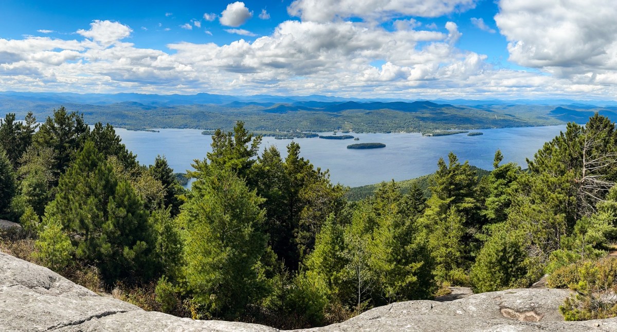
At 2:10pm, a little less than 2 hours after starting, we sat down in the sun to have some lunch and enjoy the gorgeous views of the lake.


We packed up to head back after about 20 minutes and noticed ice on the trail! In August?!

Just before heading down, we went down a little spur trail for another view.


There was a really large group ahead of us at the overlook, so we scampered right along to pass them and make our way down the mountain.

We were CRUISING on this mountain. Anyone who’s been following my journey for a while knows that I’ve been struggling with debilitating knee pain (and so much more if I’m being honest) for the last several years, until I was diagnosed with Ehlers Danlos Syndrome. Read more about that on the right side of this page – but I’m very happy to announce that I’ve finally found a system to help with me knees! Cycling class! I go twice a week and since I started, I notice I can now climb many of the same mountains without braces or poles, when before I would have had pain even on just the littlest mountain. I’m working on these 12sters to get back into shape for the high peaks, building up distance and endurance again, so to do a 6.6 mile hike with no pain was pretty monumental!

This was almost definitely the fastest I’ve ever descended a mountain. For once, I was passing people on the way down. Me! That never happens. Someone must have been having a rough day though because we found just the sole of a shoe in the middle of the trail, still at least 1 mile or two from the trailhead.

We made it back to the trailhead right at 4pm, about 3hr 45m after we started. It would have been even faster if we didn’t have to stop a gajillion times to have the dogs sit off trail so people could pass! Until next time…happy hiking!
Buck Mountain: 2334′
Total Duration: 3.75hrs
Round Trip Distance: 6.6 miles
All images are property of adktrailtalesandtails and may only be used with express permission.

Buck Mountain has always been a favorite, such great views from the top! You guys were hauling!
LikeLiked by 1 person
Yeah we were! I really enjoyed this one too
LikeLike