7/16/17
It’s been a couple of weeks since I climbed Nippletop and Dial, and with my PhD dissertation defense looming over me (it’s on the 24th of this month, and I’m dreading it), I desperately needed to get into the mountains. I signed in at the trailhead at the ADK Loj at exactly 6am, grabbed a rock to take to the summit, and set off.


The trail was nice and wide and flat, with nice puncheon and walkways throughout. A few times, I had to check the map because the trail intersected with several ski trails, but I just continued straight, following the blue trail markers.


Not long after starting, I came across a junction sign and followed the path towards Avalanche Lake, 4 miles away.

Most people climb these three mountains by going right at that first sign to hit Wright first, then Algonquin, then Iroquois, then BACK OVER Algonquin, then back down the way they came up. I was determined to make this hike a loop by going up the steep pass after Avalanche Lake, going up to Iroquois, then to Algonquin and Wright.

Half an hour later, I came upon a trail sign for Mt. Marcy, and Marcy Dam followed shortly afterward. The dam itself wasn’t crossable, but a sign led me down towards a nice bridge.


Moments later I encountered another junction sign and went right to continue towards Avalanche Lake. 15 minutes later I came across another bridge over the brook, and took the opportunity to sit on a rock and have a snack.


Yet again, only a few moments after I left the bridge, another junction sign pointed the way towards my destination. Up until this point, I’d been leap-frogging with another hiker (Chris!) and we’d continued to do so all the way up to the summits, so I passed him up and continued on my way.


I knew I was starting to get close to the lake when I started feeling like I was in Nelson’s Ledges (look it up…then book a trip to Ohio).


I crossed another little bridge along the way, and when I turned to look behind me I saw the most perfect spider web catching the light from the morning sun.


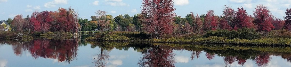
At 8am, I made it to Avalanche Lake and it took my breath away.

I went right, slogging through the thick mud, and was super grateful for my gaitors. I followed the trail for just a few minutes before stopping on a big boulder to enjoy another snack and take a few photos.

The trail around the lake was tricky, and included awesome hitch-up Matildas (which are being replaced in August, and are named for a story about a woman named Matilda Fielding back in 1868), giant boulders to climb over and between, and steep ladders. It was a ton of fun.


Good thing they’re being replaced, because this one was missing a board. I’m glad I wasn’t there when that happened!


I reached the other end of the lake an hour later at 9am, and another register just a few minutes later.

The trail was so luscious and green after that point, and several minutes later I crossed another bridge.


After I crossed it and started to descend again, I looked back up and saw a junction sign that I had missed on the other side of the bridge. I’m so smart guys, because I decided, ‘Nah, This path feels right!’ and unknowingly proceeded 0.25 mile in the wrong direction. I reached this little outpost, and a junction sign thereafter, at which point I took out my map to figure out where the hell I was.

Just as I was reaching the conclusion that I had to backtrack, a group of badass backpacking women came through and set me on the right path, back at the junction I stupidly passed.

I was back on the right path at 9:40am, and the path immediately started climbing and following a beautiful brook full of waterfalls.


At one point, I reached the top of the falls, and the trail actually went out into the stream bed. It was so incredible to be up there, looking up at the falls.


Despite being overwhelmingly beautiful, this trail was *expletive of your choice* BRUTAL. It involved tons of boulders to climb up, and the trail continued to follow the stream, often being directly IN the water. I was baffled at how there was water when I was up so high. Where does it even come from?? The ground, I guess, but…I just don’t know. This trail was sort of becoming my own personal hell. It just kept GOING, and going and going and….I seriously considered more than once that I had never actually woken up that morning, and was instead having a nightmare about being on a neverending stairmaster.

I was frustrated, tired, and getting a bit lightheaded from the constant UP, when I met a small group of people who asked where I was headed. I told them, Iroquois, and they looked at me confused and said I was going up Algonquin. My stomach dropped. They asked how far down until they would reach the top of Boundary….I asked, were they certain the junction wasn’t behind them? Because the trail I was on literally hadn’t stopped ascending, for even a second, since I had started it. I left them there to consider their options while I continued up, certain that I hadn’t reached the junction yet. After seriously questioning my life choices for a few moments, lo and behold, I FINALLY reached a large cairn at 11:30am, to the right of which was the looming Algonquin, and to the left was a narrow, overgrown trail that could be easily be missed by anyone.

The views were beautiful, and the ascent up to Boundary Peak was quick and painless. I was so excited, the pain in my legs and feet just faded away. Boundary peak was supposedly named because it was the boundary between the Iroquois and Algonquin Native American tribes., however I’m not sure how true this is. Despite being 4,829 feet high, is not considered a high peak because it does not have enough prominence.


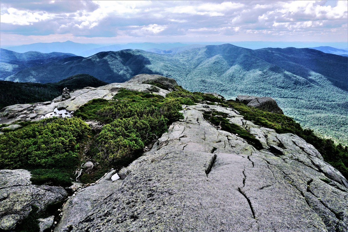
At about Noon, I had reached the impressive summit of my 14th high peak, Iroquois!


The views were phenomenal, with complete unimpeded 360 panorama. I immediately sat my butt down and ate my sammich and victory chocolate.


I enjoyed seeing the beastly trail around Avalanche Lake and up to Boundary from the summit.

While there, I met many awesome people, including the trio that had unintentionally given me a heart attack. We chatted for a time (shoutout to Matt Cook!) and took photos for each other.


I ruefully left the summit at about 12:45pm, and made it back to the junction 15 minutes later to look up at the monster Algonquin.

The way up Algonquin was steep and exhausting, but the thought of the views at the summit kept my feet moving.

20 minutes later and I was sitting near the summit ripping my boots and socks off of my blistered feet to roam around barefoot. I HIGHLY recommend this! It was made even better by the fresh clean socks I kept in my pack for afterward, so I wouldn’t have to put the same nasty socks on again.


I enjoyed my time at the summit for about an hour, talking with a bunch of awesome people and enjoying another snack (of course). I spoke with one group who had brought their friend up for his first ever mountain. Not even first high peak, but first MOUNTAIN. This guy was hilarious, he was just yelling nonstop about how he couldn’t believe how amazing it was, and making phone calls to presumably ever person he had ever met to tell them he was on top of a mountain. It was really funny to witness, and I had to turn away to stifle my laughter, noticing as I did that several other people were doing the same.


I took my turn at the summit to take a photo of my beat-up feet with the geo marker.

At 2:15, I began my descent and deposited my rock at the pile designated by a small sign on the way down.


The descent was stunning, walking above the treeline to see out to the mountains around me.


Along the way, I joined with another hiker making his descent (shoutout to Fred) and we had a fun time talking, until I fell flat on my ass on my way down a slippery, steep rock slab. Nothing was hurt, besides my dignity (and some scrapes on my hands) and we carried on our way.


Below the treeline, the descent was quite steep and time consuming. I finally reached the junction to Wright Mountain about an hour after leaving the summit, and turned to head straight back up.


It was only 0.4 miles to the summit, however it was exceptionally steep and I was very nervous about coming back down. Nevertheless, I put one foot in front of the other and was soon above the tree line, once again.


Towards the summit, there was a little sign pointing right towards the summit, and left towards the plaque for the plane wreck. In 1962, a B-47 bomber practicing low-altitude bombing runs over Watertown veered 30 miles off course in inclement weather and high windes, when the wingtip clipped the summit of Wright Mtn. The mountain shattered the plane, scattering the wreckage along the southwest side of the peak. Read more about the accident here.

I popped right up to the summit, where a couple was hanging out shouting Tarzan-like ululations, and we took photos for each other.


I was on a bit of a tight timeline, wanting to be back at the trailhead at 6pm, so I stayed at the summit for all of 5 minutes before heading down to explore the plane wreck.

Just a few minutes of descent and I was at the plaque with the scraps of debris.


I scampered back up to the peak, and began my descent at 4pm.

Surprisingly, despite seeming so steep on the way up, the climb down really wasn’t that bad, nor did it last very long. After 20 minutes, I was back at the junction to Algonquin. The descent after that point was rather rocky and steep, and I really had to take my time. That stupid song from one of those puppet christmastime cartoons started playing in my head, and it drove me a little bit more insane, the one that goes “put one fooot in front of the other, and soon you’ll be walking out the dooooor”. UGH. Of all things to be in my damn head. Anyway, after an hour of that, I made it to a nice waterfall where another group was hanging out. I took the opportunity to rest my feet and have another snack.

After that point, the trail was significantly easier, finally with some flat dirt path instead of constant rockhopping. For once in my life, I was passing everyone on this trail! I was not the slowest person on the mountain! But really though, this NEVER happens. A few uneventful miles later and I was back at the trailhead, signing out at about 6:20pm, 12hrs 20mins after I began. I headed straight to my car, changed into clean clothes to try to pretend like I didn’t stink as much as I did, and headed home.


This was absolutely my favorite climb, to date. Every single summit had complete 360 degree views, it was a beautiful day, and I felt so accomplished at having taken the tougher route to climb these three. 16 down, 30 to go!
Iroquois Mountain: 4,840 feet
Algonquin Mountain: 5,114 feet
Wright Mountain: 4,580 feet
Boundary Peak: 4,829 feet
Round Trip Distance: 13.4 miles
Total Elevation Gain: 4300′ feet
Total Duration: ~10 Hours of hiking +2 Hours at summits
All images are property of adktrailtalesandtails and may only be used with express permission.

Nice trip report! I just finished defending my Masters Thesis a few weeks ago so I can relate to what your feeling!
LikeLike
Thanks! Isn’t it the worst? At this point, I’m just ready for it to be over so I can carry on with my life. Happy hiking!
LikeLiked by 1 person
Isnt that the truth. Im still in the process of final revisions and adding in data I didn’t get back until after the defense. Fun stuff.
Thanks for the follow as well! Look forward to hearing about your 46er journey!
LikeLiked by 1 person
Thank you for an awesome report! This exact route was the first hike I did towards my 46 and I was able to re-live it with your report!
LikeLike
And btw…..I climbed these on 7/16/16!!
LikeLike
Woah! It’s a good day to climb these three, I guess!
LikeLike
Just stumbled on your site – no pun intended- I am considering the same route.
Do you know if dogs are allowed on these particular trails – I know some of the initial trail systems in the high peaks do not allow dogs. Also if dogs are allowed, in your opinion do you think it is passable in some of the trickier areas (ladders) with a dog, enjoy reading your stories. thanks.
LikeLike
Hi! To my knowledge, the only trails that dont allow dogs are those that start on AMR land (ausable club/ lake rd). What kind of dog do you have? I think in general dogs would do just fine here. I dont bring mine because she purposely rocks and boulders to jump off of and I worry about her joints. In this case, the path up boundary would be my only concern. Happy trails!
LikeLike
Great story and photo log! Impressive day. I just got back from doing Haystack, which was #14 for me. I can relate the determination to loop and was of similar mind this week, hoping to add Basin and Saddleback before looping back to John’s Brook Valley… but I thought better of those two steep faces in a very deserted wilderness, just me and dog, not to mention being too wiped out to face two more peaks after Haystack. So easy to underestimate peaks and distance on paper.
Avalanche Lake was my first ever backpacking experience in the mid-90s. And I did
Algonquin/Boundary-Iroquois/Wright via the more traditional route in 2007 (although I have no memory of the Boundary/Iroquois leg, just the highlighted map as my record!)… so your pictures brought back a lot of great memories. Thanks for taking the time to share the story.
(BTW… you’re not the only one to get the insidious one-foot-in-front-of-the-other song stuck in one’s head for miles on end. Brutal.)
LikeLike
Thank you so much for your feedback, and your story! I can’t wait to get back into these long multipeak hikes and documenting them. Hopefully soon 🙂
LikeLike